MMR Sample Maps
To check out a video highlighting the various "layers" of information you can add to your custom map, click here!
Custom Map (deer blinds, feeders, roads & more!)
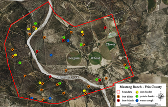
This map was created by one of our clients in Lee County, who wanted to have all of his deer blinds and feeders labeled on his map, as well as his roads and where the streams ran through the property. This client went with our standard 3' x4' map, along with field maps, and our latest product, a Brute cooler lid top map (featured below).
Click on the picture to your left to get a larger view of this map, so you can see what kind of custom features we can provide for a map of your property.
Click on the picture to your left to get a larger view of this map, so you can see what kind of custom features we can provide for a map of your property.
Field Maps

Most of our customers wish to have a large poster-sized map and a smaller field maps to keep in their vehicles, backpacks, or to use in the field. We can create them with GPS coordinates, to know exactly where you are in the field, or with other various levels of data (topo, flood plain, etc).
Bison Cooler Top Maps
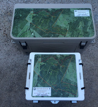
We have teamed up with the folks at Bison Coolers, to provide high quality cooler top maps for owners of Bison coolers. Their coolers are available in 25, 50, 75, 100, and 150 QT sizes. These maps are easy to adhere to your cooler. They are UV resistant, have an anti-skid texture, and extremely durable!
Click on the picture to your left to get a larger view of the Bison Cooler Top Map.
If you are interested in purchasing a Bison Cooler from us, click here to learn more.
Click on the picture to your left to get a larger view of the Bison Cooler Top Map.
If you are interested in purchasing a Bison Cooler from us, click here to learn more.
Scale Resolution Prints
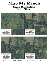
Larger properties will look great with any sized maps, but if you only have a smaller piece of property, a large map will appear blurry, as the scale resolution will be too "zoomed in." This sample just illustrates what we mean by the various levels of resolutions and scale.
Click on the picture to your left to get a high resolution 8.5 x 11 .pdf file that you can print out, to see the variations in the resolutions.
Click on the picture to your left to get a high resolution 8.5 x 11 .pdf file that you can print out, to see the variations in the resolutions.
100 Year Floodplain Map Sample 1
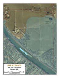
In this map, we were asked to show where the 100 Year Floodplain extended, around an area where a developer was looking to buy some property. We labeled some of the major roads and river, as well as showing the property lines of the adjacent owners.
Click on the picture to your left to get a high resolution file that you can print out, to see an example of how your Floodplain map will look!
Click on the picture to your left to get a high resolution file that you can print out, to see an example of how your Floodplain map will look!
Elevation map with 100 Year Floodplain
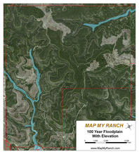
For this map, a client wanted us to provide him with the elevation of his property, and show were the 100 Year Floodplain extended into his ranch.
Click on the picture to your left to get a high resolution file that you can print out, to see an example of how your Elevation and Floodplain map will look!
Click on the picture to your left to get a high resolution file that you can print out, to see an example of how your Elevation and Floodplain map will look!
Latitude/Longitude Grid Map
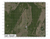
A client of ours was going to do a walk through of his property to figure out where to put his deer stands and feeders for the upcoming hunting season. We had provided a large map for his ranch house wall, but he wanted something smaller to carry around with him. We produced a series of 8.5 x 11 inch maps, that we laminated, showing the latitude and longitude lines of his property, that he could easily put in his day pack (or even fold up in his back pocket). He simple turned on his GPS app on his cell phone and no matter where he was on his property, he could use his GPS and map to know exactly where he was. As a bonus, he could also determine distances between improvements he was going to make, based on the scale we provided on the key map.
USGS Topographic Map
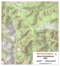
USGS Topographic Maps can be extremely useful! When Colin and I went to Big Bend National Park, we printed out a few of these, so that we could do some off trail back packing, and not get lost! When you are out on a trail, it's easy to tell when the elevation begins to change rapidly, but if you are adventurous and you like to walk up and over various ridges, you can sometimes get turned around. I know for a fact that it came in handy many times throughout the day. The next time we went, we decided to cover more ground, and we printed out a few maps that had points we plotted on our GPS devices when we were hiking the previous time, as landmarks and cool scenic areas to check out again. It's amazing how beneficial a GPS and a good map can be. As great as the GPS apps can be for your phone, without cell service, you will need to rely on your GPS...have both for every hike! Be safe, and have fun!
